The GIS browser is an important tool for getting information about a specific site. The data that you can get, ranges from simple contour lines to noise pollution data. It is definitely worth spending some time to investigate the different maps and options of the tool, in order to find the ones that might be of use to your project.
For landscape and terrain models we focus on two sets of data that are of special interest to us. The first one contains the terrain information, contour lines, and is called: Isohypsen DTM – 2017/2018 and the second one contains all the cadastre data (e.g. streets, houses, bridges and so on…) and in the case of the Canton of Zurich is called: Amtliche Vermessung – Datenmodell Kanton Zürich (DM01AVZH24). Both data sets can be downloaded as .dxf-files for further processing in any CAD software.
Note
The data that we get from the website is a great starting point, but is unfortunately far from being useful for anything else than printing. If you want to use our laser cutters or cutting plotters to make a landscape model, you will soon discover that both .dxf-files are full of problematic line definitions. In order to minimize this source of great frustration we created our own Isohypsen-plugin for Rhino3D that helps you with creating cleaner data for your models.
See this post for more information on the plugin and file preparation!
Geobau (DM01AVZH24) Layer Definitions
It is worth to studying the layer definitions of the cadastre data in order to get the layers that are useful to your project and discard unnecessary geometry that makes your files heavy and hard to handle. Information about the layers and the exact content can be found here: GEOBAU2 Format
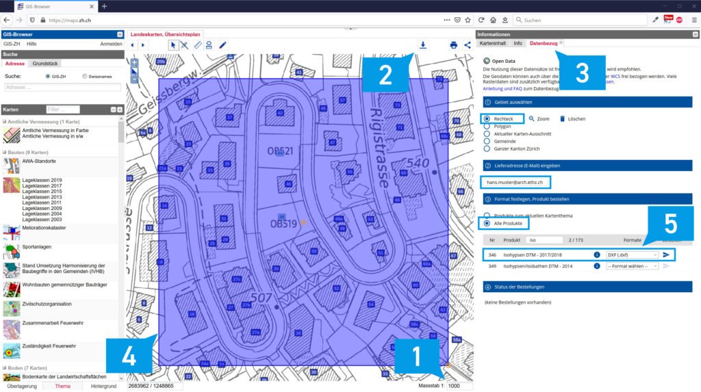
GIS Browser Step By Step
Use zoom and pan to get close to your desired plot
Select the appropriate scale (1) for your model (e.g. 1:1000, 1:500)
Press the download button (2)
Follow the instructions in the “Datenbezug”-tab (3) to select your perimeter (4), specify your email address and to choose the download options
Under “Format festlegen, Produkt bestellen” select “Alle Produkte”
Search for Product “Isohypsen DTM – 2017/2018” and download as .dxf-file (5)
Search for Product “Amtliche Vermessung – Datenmodell Kanton Zürich (DM01AVZH24)” and download as .dxf file (5)
If you are planning to build a Landsacpe model, proceed by klicking here to use the Isohypsen Plugin For Rhino3d.